Mount Ophir, also known as Gunung Ledang, is located in Gunung Ledang National Park. The summit lies near the border between Muar and Melaka. Standing at 1,276 m, it is the highest peak in Johor and the 64th tallest mountain in Malaysia, including Sabah and Sarawak. It is possibly one of the most frequently climbed mountains in Malaysia.
The main trail from the Johor side is the Lagenda Trail, also known as the Sagil Trail due to its proximity to Sagil Village. The starting point of the Lagenda Trail is at Taman Hutan Lagenda, where the park office and accommodation facilities are located. There are altogether seven checkpoints before the summit: CP1 – Bukit Semput, CP2 – Batu Orkid, CP3 – Laluan Kijang, CP4 – Kolam Gajah (Elephant Pool), CP5 – Sungai Tiga Segi (Triangle River), CP6 – Gua Kambing (Goat Cave), and CP7 – Bukit Botak. Some climbers also start from Gunung Ledang Resort, which is about a five-minute drive from Taman Hutan Lagenda. If you start from Taman Hutan Lagenda, you will bypass CP4. A short distance from CP3 is a T-junction where the route on the right leads to CP4, while the route on the left leads towards CP5. After CP3, it is downhill all the way to CP5.
The most exciting and challenging part of the trail starts from CP5 onwards, with an average slope of more than 40 degrees, based on my own estimate. There are permanent ladders and ropes along this section of the trail to assist climbAers. The steepest part of the climb, known as “KFC”, is located between CP5 and CP6. Some people believe the acronym stands for “Killer for Climbers”. You will be climbing on all fours and using almost every muscle in your body to scale this section! The main trail from the Melaka side is the Asahan Trail. The trail starts beside the Asahan waterworks near Asahan Village. Similar to the Lagenda Trail, there is also a park office at the beginning of the trail. All climbers need to register at the park office before beginning their climb.
The great majority of climbers scale the summit via the Lagenda Trail. One of the reasons why the Asahan route is less popular is its relative inaccessibility compared with the Lagenda route. Asahan is about 24 km from the major town of Tangkak, whereas Sagil is less than 10 km from Tangkak. However, the Asahan Trail is shorter, less steep and wider than the Lagenda Trail. I had climbed Mount Ophir via both trails before. I would say that the Lagenda Trail is much more challenging and interesting than the Asahan Trail.
We chartered a Malaysian-registered van to bring us from Singapore to Mount Ophir. The van picked us up at Serangoon MRT Station at 6.30 am. The original pick-up time was actually 5.30 am, but the van arrived an hour late. We reached Mount Ophir at around 9 am. The distance from Singapore to Mount Ophir is about 210 km. Normally, it takes more than three hours to reach Mount Ophir from Singapore, including the time required for immigration and customs clearance.

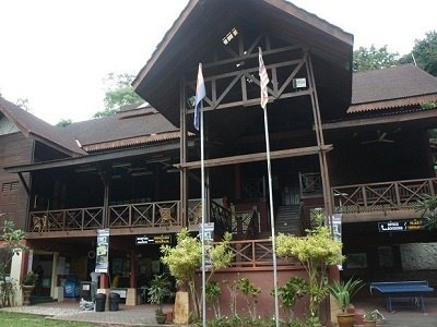
Taman Hutan Lagenda is managed by Taman Negara Johor Gunung Ledang. In the past, visitors had to drive through a palm oil estate for some distance before reaching it. More recently, a tarmac road was built to connect it directly to the main road, Malaysia Federal Route 23. The climbers’ registration office is located directly in front of the entrance. All climbers are required to fill in a form declaring the items they are carrying with them for the climb. At the end of the climb, climbers have to show the declared items to the ranger to prove that they did not throw away or leave any of them on the mountain. After registration, all of us gathered in front of our mountain guide, Pang, for a briefing on safety and the ground rules. The registration and briefing took less than 30 minutes to complete. We started the climb at around 9.45 am.
The trail begins with a flight of more than 500 steps, after which it becomes a mountain trail, with some sections involving boulder climbing, all the way to the summit. It took us about 20 minutes to reach CP1 – Bukit Semput from the starting point. From CP1, it took us another 20 minutes to reach CP2 – Batu Orkid. It took us about 30 minutes to reach CP3 – Laluan Kijang from CP2. From CP3, the usual route is to proceed towards CP7 via CP5, KFC and CP6. As we were short of time—it is recommended that climbers start before 8.30 am so that they can return to the park office before dark—our guide took us along another route that bypassed CP5, KFC and CP6 and led directly towards CP7. We completely bypassed KFC, located between Sungai Tiga Segi and Gua Kambing, which is the steepest part of the usual trail. On average, the normal route via CP5, KFC and CP6 takes about five hours from the starting point to the summit. By taking the alternative route, we reached the summit in less than four hours. However, this route is considered less scenic than the usual one. We took about two hours to reach CP7 – Bukit Botak, the last resting point before the summit, from CP3. Some of us who had climbed Mount Ophir before felt that this shortcut was less strenuous than the usual route. At CP7, we did not see any signboard indicating its location. I also did not take any photographs of the resting point, so unfortunately I have no photograph of CP7 to show here.

There are one or two streams along the way where you can replenish your water supply. Water sources higher up the mountain, particularly above CP5, are usually clean enough to drink without boiling or filtration. One of us tried drinking the water directly without suffering any side effects. However, to avoid the hassle of replenishing your water supply along the way, you should carry at least two litres of water for the entire climb.
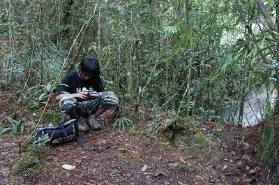
Our trip took place on 21 July, which coincided with the second day of Ramadan. Pang was fasting, and he completed the entire climb without any food or drink. Even though we were late starting the climb, he did not show any sign of impatience or annoyance. Kudos to his professionalism! It took us about 45 minutes to reach the summit from CP7.

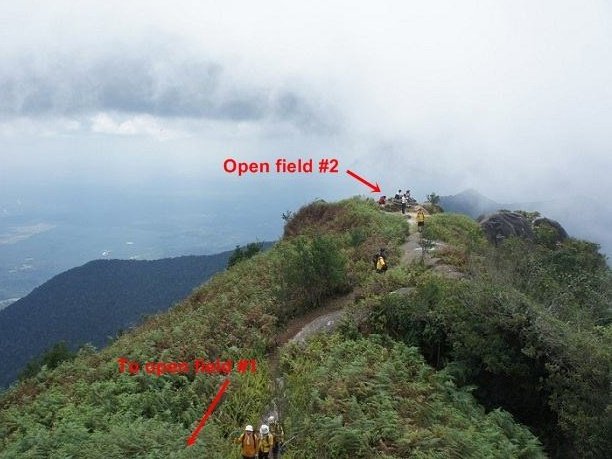
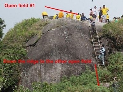
The summit consists of two open fields connected by a narrow ridge. The summit plaque is located in the first open field. From the summit, Melaka and the Straits of Malacca are visible on a clear day. For the descent, we followed the same route that we had taken on the way up, meaning that we again skipped the KFC section. It took us about four hours to return to the mountain base.
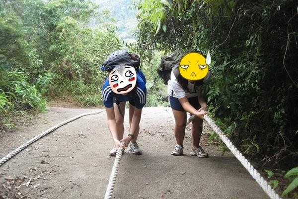
The above photo was taken during one of my earlier trips to Mount Ophir, when we descended from the mountain via the KFC section. The photo does not really show just how steep the slope is. I would estimate that it has an inclination of easily more than 50 degrees. The two ladies in the photo were descending a gigantic slab of rock that was more than three storeys high. There are also several waterfalls within the nature reserve. One of the better-known ones is Puteri Falls, named after a legendary princess. It is located a few hundred metres from Gunung Ledang Resort, which itself is a few kilometres from the park headquarters.

Leave a Reply